
|
Sale 43
Manuscript and Collectibles Auction
| Lot |
Photo |
Description |
Realized |
Lot 562 |
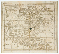 |
America Settentrional - by Sanson. 6" x 7" Italian edition of Sanson's famous prototype, showing California as an island, 1650/1656 map of North America, this published in Italy circa 1690. Small decorative title cartouche; upper left corner has "Tom. I". Rather than the more common flat northern California coastline sloping up to the east, this has the much scarcer indented northern coastline with "R. de Eslite" at the tip. McLaughlin & Mayo ("California as an Island") identify editions in French, Dutch and Latin, but none in Italian. There is a light water stain in the upper left corner, and ink stains in the center of the image and in far right margin. Soiled, with separation at folds reinforced. Matted but unframed.
Estimated Value $300 - 400.
View details and enlarged photo
| Realized
$173 |
Lot 563 |
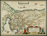 |
Beautiful Antique Map of the Holy Land by William Blaeu 1629. "Terre Sancta quae in sacris Terra Promissionis olim Palestina Amstelodami officina Guiljelmi Blaeuw 1629". Printed area 15" high x 19 1/2" wide, in full old color with double page Dutch text on the back. The seas with a pair of compass roses, an ancient ship and three fierce creatures. Considerable detail is seen in the interior, cities, towns, mountain ranges and the two famous bodies of water, the Sea of Galilee and the Dead Sea. A lovely fully colored cartouche at lower right includes Moses holding the tablet with the Ten Commandments and a second ornately dressed figure at right. This lovely map, printed in Amsterdam by William Janszoon Blaeu (1571-1638), the founder of one of the great mapmaking family firms, is in very good condition and has been handsomely matted and ready for framing. Scarce in this nice state of preservation.
Estimated Value $1,250 - 1,500.
View details and enlarged photo
| Unsold |
Lot 564 |
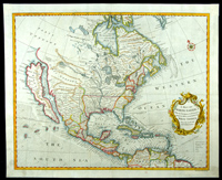 |
C. 1745 Map of North America Showing California as an Island. "A Map of North America With the European Settlements & Whatever Else Is Remarkable In Ye West Indies From the Latest and Best Observations", by Richard William Seale (1732-85), ca. 1745, printed in London for Tindal & Rapin.
Shows all of North America from the Arctic Circle to the northern part of South America and includes the Caribbean Islands. California is shown as a huge island having an extensive mountain chain down its center, with the "Gulf of California or Red Sea" seperating it from the larger continent.
Measures 18" x 15", with lovely old color and in excellent condition on firm crisp paper. Among the nicest examples of this scarce and popular map that one will see and most suitable for framing and display.
Estimated Value $2,500 - 3,000.
View details and enlarged photo
| Realized
$2,300 |
Lot 565 |
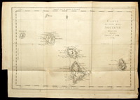 |
Carte des Isles de la Société découvertes par le Lieut.t J Cook. 1769. 13½" x 18" map from a French atlas (Tome III Pl. 1re.), showing islands discovered by Lieut. (later Capt.) James Cook on his first voyage to the South Pacific. The islands are Bola Bola (Bora Bora), Otaha, Ulietea, Huaheine, Maurua, and Tubai. Printed on laid paper. Very good; light toning and soiling. The Royal Society in London placed Cook in charge of an expedition to Otaheite (Tahiti) whose purpose was to observe the transit of Venus across the sun in June 1769. After leaving Otaheite in July 1769, Cook visited the islands on this map and raised the Union Jack there. This was the first of Cook's three trips to the South Pacific; he was killed during his third voyage by natives of Hawaii (1779).
Estimated Value $400 - 600.
View details and enlarged photo
| Unsold |
Lot 566 |
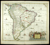 |
Handsome Large Mid 1600s Antique Map of South America by Jansson. "America Pars Meridionalis", by Jan Jansson, published Amsterdam, ca. 1640. Printed area 18" high x 21 1/2" wide plus margins, in original outline color with a fully colored cartouche. From the north, including parts of Central America and the Isthmus of Panama to the Straits of Magellan and Cape Horn in the south. Interior details show a hunting scene, dwellings, village life, wild animals and in both oceans, sailing ships, native boats and sea monsters. The mouth of the Rio de la Plata is huge with myriad large islands upstream and a very sizeable lake is seen to the northeast. The large cartouche portrays six adult natives and one child along with flora and fauna. Only slight aging of the paper at the edges, otherwise this rare and important map is in excellent condition.
Estimated Value $550 - 750.
View details and enlarged photo
| Unsold |
Lot 567 |
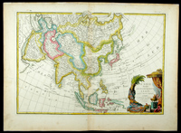 |
Lovely Janvier 18th Century Map of Asia, with a hint of Alaska, including Philippines, China, Japan, Korea & India. "L'Asie divisee En Ses Principaux Etats par le Sr. Janvier, Geographe, a Paris." Ca. 1760s, 12 1/4" high x 17 5/8" wide copperplate engraving with original outline color and a striking fully colored cartouche in an exotic far eastern motif. This handsomely rendered map by Jean Janvier, covers from the western Mediterranean to Kamchatka in the north, and from the Red Sea and horn of Africa to the Philippines and Indonesia in the south, and all else between. A shadowy presence in the Bering Sea hints at the Alaskan coast with the caption "Terre vue par (land seen by) Tchiricoive et DeLisle en 1741." There is minor age tone at the margin extremities, otherwise very good condition. Scarce and attractive.
Estimated Value $450 - 650.
View details and enlarged photo
| Unsold |
Lot 568 |
 |
Lovely Mid-18th Century Map of Mexico or New Spain. "Carta Geographica del Messico O Sia Della Nuova Spagna" by Guillaume De L'Isle (1675-1726), from the Italian edition of his Atlas Nouveau, 1740-50. Measures 17" x 13", depicting Spanish Lands from the Rio Grande south to Costa Rica, mentioning the important audiencias and cities. At upper left the western edges of Florida and Cuba. Two sailing ships in the southern ocean and at lower left an intricate fully colored cartouche shows a farming scene and two captive natives, one wearing a crown, at the feet of a nobleman and his lady. Excellent condition with bright white paper and attractive coloring. Handsomely matted and ready for framing.
Estimated Value $500 - 750.
View details and enlarged photo
| Realized
$575 |
Lot 569 |
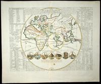 |
Plan de l'Histoire Universelle…by Chatelain. Circular globe showing "the four monarchies of the world, and all the ancient states, as well as those that exist today," (Amsterdam, 1719); image measues 13¼" x 17½" on a 17" x 20½" sheet. From Chatelain's Atlas Historique. The Eastern Hemisphere is emphasized; the Western Hemisphere is inset, with California as an island. Small vignettes of the seven wonders of the world are arranged below and extensive tables and text at the sides lists the rulers of the four "monarchies": Assyria, Persia, Greece, and Rome and other information. The present-day U.S. is represented by New England, Virginia, and Florida. One small spot at lower cent of image; otherwise in nice condition.
Estimated Value $550 - 650.
View details and enlarged photo
| Unsold |
Lot 570 |
 |
Rare 1756 Map of the Eastern United States and Canada showing the British Colonies, Virginia & Ohio. "America Septentrionalis A Domino D'Anville In Gallis Edita Nunc In Anglia Coloniis In Interiorem Virginiam Deductis Nec Non Fluvii Ohio Cursu", by Homann Heirs, dated 1756 and printed in Nuremberg. Dimensions 20" x 18", with original outline color. Extensive German text at lower right and upper left. Covers eastern Canada and its maritime provinces south to the Gulf of Mexico. Important as depicting the progress of colonization west to the Ohio River Valley, and mentioning the lands of the various Indian Tribes encountered. Some age toning of the paper, otherwise very good condition.
Estimated Value $1,200 - 1,500.
View details and enlarged photo
| Unsold |
Lot 571 |
 |
Superb 18th Century Map of Hawaii, the Sandwich Islands, Showing the Route of Cook's Third Voyage When He Was Killed. "Carte des Isles Sandwich, Par M. Bonne, Ingenieur-Hydrographe de la Marine." Printed in Paris, ca. 1780. A copper plate engraving with full old hand color, printed area 13 1/2" by 9 1/4". Each of the islands is shown and named; Oneeheow, Atooi, Woahoo, Morotoi, Ranai, Tahoorowa, Mowee and Owhyhee. At upper right a compass rose and at left a large inset view "Plan De La Baye De Karakakooa 1779." At upper left, above the border "Cook 3e Voyage". M. Bonne' son Rigobert, the map's engraver, traces Cook's third voyage's route through the islands from 26 November 1778 through 15 March 1779, and dates the various stops along the way. One event not noted, and possibly not yet known to the French, was Cook's death on Feb. 14, 1779 on the island of Hawaii. An exceptional specimen, handsomely matted and framed to an overall size of 20" by 15" and ready for hanging or display.
Estimated Value $1,250 - 1,500.
View details and enlarged photo
| Realized
$1,898 |
Lot 572 |
 |
Superb Quality Map of Japan Dated 1752. "Carte de l'Empire du Japon Pour servir a l'Histoire Generale des Voyages", Paris, 1752 by Jacques Nicolas Bellin (1703-72), as issued from the Histoire Generale des Voyages. Printed area 12 1/2" x 8 1/2". A boldly impressed black on white engraving as originally issued, with baroque cartouche at upper left. This interesting view of the Japanese islands is still quite speculative and distorted indicative of the lack of accurate coastal surveys available to Parisian mapmakers of the period. Excellent condition, nicely matted and ready for display or framing. Scarce this nice.
Estimated Value $400 - 600.
View details and enlarged photo
| Unsold |
|
|