|
Sale 79
| Lot |
Photo |
Description |
Realized |
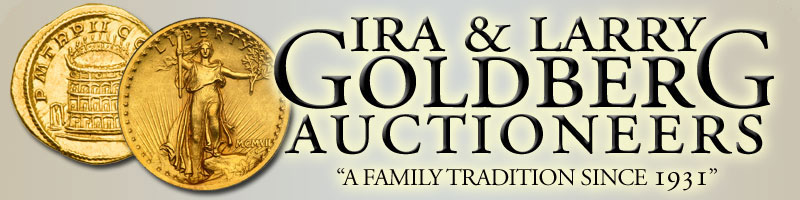
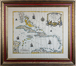
Lot 300 |
 |
Typvs Chorographigvs, Celebrivm Locorvm in Regno Ivdae et Israhel. Handcolored engraving, by Abraham Ortelius, c. 1586. Prepared by Tilemano Stella, a German cartographer who made maps of Germany and the Holy Land. Image: 13 7/8 x 18", matted and framed to an overall size of 23¼ x 27¾". A lavishly engraved map of the Holy Land, divided into the kingdoms of Juday and Israel. With two beautiful, elaborate cartouches. Place names and territorial divisions are drawn on Biblical sources. The shoreline extends from Beirut to El-Arish. Inland, Palestine is shown on both sides of the Jordan River. The map extends as far south as the Dead Sea. The map is dated 1586 but wasn't published until 1590, probably denoting the extensive effort put into the engraving. Not examined out of frame.
Estimated Value $800 - 1,000.
View details and enlarged photo
| Realized
$1,260 |
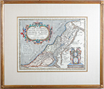
Lot 301 |
 |
Parte della Nuova Spagna, ò del Mexico, doue sono le Prouincie di Guadalaira Xalisco Mecoacan e Mexico. By Italian cartographer V.M. Coronelli, Venice, 1680. Handcolored. Plate size: 18" x 23½; sheet size: 20½" x 26¾". Attractively framed to 26½" x 32¾". Depicting central Mexico and the Pacific coast. Two decorative cartouches and two sailing ships. At lower right Coronelli notes that he has published other maps, especially of South America, that are also being sold in Paris.
Estimated Value $700 - 900.
View details and enlarged photo
| Realized
$870 |
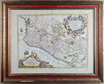
Lot 302 |
 |
America Septentrionalis by Homann Heirs, Nuremberg, dated 1756. An important French & Indian War era map showing the entire eastern seaboard from British North America to northern Florida, and from the Atlantic far west into lands labeled with names of the Indian tribes who inhabited them, i.e., the Asiniboels, Illinois, Miyamis, Chikasaws, Chactaw, etc. Printed area, 20" x 18.5" with extensive original old color. A large German text describes the land masses depicted, these a few years later the locations of many important Revolutionary War Battles. Light overall age tone, otherwise very good condition. We note several current offerings in the $1250-2250 price range.
Estimated Value $700 - 900.
View details and enlarged photo
| Realized
$780 |
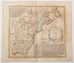
Lot 303 |
 |
Partie de la Mer du Nord où se trouvent Les Grandes et Petites Isles Antilles et les Isles Lucayes. By French royal geographer, Robert de Vaugondy, mid 18th century. Handcolored. Engraved by Guillaume Delahaye. Plate size:19 x 23"; sheet size (visible) is 22½ x 26¾". Attractively framed to 28½" x 32¾". Showing the lower portion of Florida down to the northern coast of South America. The islands in the West Indies include the Bahamas (Lucayas) and the islands to the east of Florida; the Greater Antilles, including Cuba, Hispaniola, Jamaica, and Puerto Rico; and the Lesser Antilles, small volcanic islands at the eastern edge of the Caribbean Sea. Decorated with a lovely title cartouche, five sailing ships, and a wind rose.
Estimated Value $600 - 800.
View details and enlarged photo
| Realized
$720 |
Lot 304 |
 |
"L'Empire De La Chine, avec La Tartarie Chinoise". Wonderful 18th century map of China by P. Santini of Venice and published by R. Bonne, Paris, 1779. A lovely large format map of the Chinese Empire, including, at the time, Korea, and also showing the Japanese island chain. Coverage extends north to Russian East Asia, to Tartarie in the west and to Laos and Cambodia in the south. Handsomely accented with original outline color and a beautifully engraved cartouche at lower right. Printed area, 21.5" wide by 19" high with extra large margins. Of special note is the superb condition…a very sharp impression on still bright white paper, obviously from a well preserved atlas. Very scarce this nice and of an area widely collected these days.
Estimated Value $600 - 800.
View details and enlarged photo
| Realized
$600 |
Lot 305 |
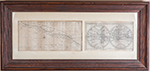 |
A Map of the World by Moll, With The South Sea Coast by John Senex. Two maps matted together and framed to 16½" x 35½". (1) A Map of the World, Shewing the Course of Mr, Dampiers Voyage Round it: From 1679 to 1691, [London, James Knapton, 1697]. Image is 7" x 11¼". Dampiers was a buccaneer, explorer and map-maker, the first person to circumnavigate the world three times; he is often credited with the European discovery of Australia. Information he collected was used by James Cook and Horatio Nelson. After his first voyage, he wrote a book, A New Voyage Round the World, based on his journals.
(2) The South Sea Coast, engraved by John Senex, 7¼" x 15½". It shows the Pacific Coast of Mexico from 8 degrees to 17 degrees north latitude and was published after a Spanish map said to have been captured by English rover Capt. Woods Rogers. It appeared in A Cruising Voyage Around the World, London, 1712. Senex was a cartographer, explorer, astrologer, geologist, and geographer to Queen Anne; he was also the creator of pocket-size world maps. Both maps with considerable toning. Not examined out of frame.
Estimated Value $500 - 600.
View details and enlarged photo
| Unsold |
Lot 306 |
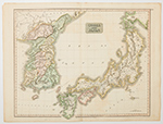 |
Korea and Japan, Early 19th Century Map. Entitled "Corea and Japan", this far eastern map is from "Thomson's New General Atlas", dated August 16, 1815. Large format (printed plate area of 25" x 20" plus margins) depicting the Korean Peninsula and the islands of Japan with, at upper right, the Russian island of Jesso. Nicely colored, with the Korean provinces especially detailed. A half inch chip off one corner and with normal age tone, otherwise very good condition. Now quite popular and getting scarce.
Estimated Value $300-UP.
View details and enlarged photo
| Unsold |
Lot 307 |
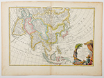 |
"L'Asie divisee en Ses Principaux Etats, par le Sr. Janvier a Paris." Ca. 1760s. Attractive 18th Century Map of Asia. Printed area, approximately 17-5/8" wide by 12-1/4" high. Expertly engraved by Janvier, this copperplate rendering presents with original outline color and a striking fully colored cartouche in an exotic far eastern motif. Covers from the western Mediterranean to Kamchatka in the north, and from the Red Sea and Arabian Peninsula in the southwest to the Philippines and Indonesia in the east, and everything in between, India, China, Russia, Korea, Japan, Philippines, etc. A shadowy presence in the Bering Sea hints at the Alaska coast with the caption "Terre vue par (land seen by) Tchiricoive et DeLisle en 1741." A bit of light age tone in the margins otherwise excellent condition. A very pretty and increasingly popular map ready for framing.
Estimated Value $450 - 650.
View details and enlarged photo
| Realized
$432 |
Lot 308 |
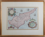 |
Cypri Insvlae Nova Descript 1573. Handcolored engraving by Joannes van Deutecum for Abraham Ortelius' Atlas "Theatrum Obitis Terrarum, "Antwerp, c. 1600. Image: 13½ x 19¼", matted and framed to 23½ x 29". A few nicks to frame. With four baroque cartouches. At lower right, inside a cartouche, is "LEMNOS INSVLAE descriptionem ex Petri Bellonij libro de Auibus, hoc in locotanguam parergon adiecimus." The seas hold three sailing ships and a sea monster. A strong impression. After 1573 Ortelius introduced a new map of Cyprus in his "Theatrum Orbis Terrarum" which was used by publishers and cartographers as a prototype for almost two centuries.
Estimated Value $400 - 600.
View details and enlarged photo
| Realized
$720 |
Lot 309 |
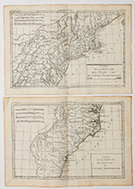 |
America. Early Use of Term "United States" on Maps. An interesting pair of maps by Rigobert Bonne, Parisian cartographer; ca. 1780, printed plate area 13 x 9" plus margins. "Carte de la Partie Nord Des Etats Unis de l'Amerique Septentrionale", and ""Carte de la Partie Sudd Des Etats Unis de l'Amerique Septentrionale". The first shows all of New England and the mid-Atlantic states south to Maryland and northwest to include Lakes Ontario and Erie. The companion map takes up at Chesapeake Bay continuing south through the Carolinas and Georgia. At the west is shown the land of "Les Cherokees". Published at about the time the Revolutionary War was ending, they are among the earliest maps to define the nation as the United States. Both in excellent condition, having just been removed from the original atlas. We note a current retail offering of a similar pair at over $500.
Estimated Value $250 - 350.
View details and enlarged photo
| Unsold |
Lot 310 |
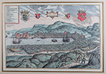 |
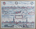
Georg Braun & Franz Hogenberg. Bergen. Handcolored bird's-eye view of Bergen (Cologne, 1580 or later). "Hieronymus Scholeus sua manu descripsit." Title in small baroque cartouche, coats of arms to left and right. Key to locations at upper left. Image: 12 5/8 x 18½", matted and framed to an overall size of 23 x 29". Not examined out of frame. After 1618 Jan Jansson aquired the plates for Civitates orbis terrarum and published an eight-volume edition. The maps were re-issued a number of times in various forms and were published for the last time in 1750.
Estimated Value $400 - 600.
View details and enlarged photo
| Realized
$234 |
Lot 311 |
 |
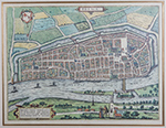
Georg Braun & Franz Hogenberg. Lippe (and) Dortmund. Handcolored bird's-eye views of Lippia and Dortmund, from Civitates orbis terrarum (Cologne, c. 1620), v.4, plate 20. In cartouche at bottom right: "Lippia opp. licet Comitib. de Lippia subsit … hec Hermannus Hammelmannus." Three armorials across top; "Dortmund" in baroque cartouche. Image: 13½ x 17", matted and framed to an overall size of 23¾ x 27¼".
Not examined out of frame. A few nicks to frame.
The Civitates orbis terrarum was one of the major works of the Renaissance, used a combination of three types of representation : The pictorial panoramic view showing the arrangement of a town's buildings situated in their topographical surroundings; the town plan - a straightforward scaled map and the bird's-eye view which is more or less a combination of panorama and plan as seen from above.
After 1618 Jan Jansson aquired the plates for Civitates orbis terrarum and published an eight-volume edition. The maps were re-issued a number of times in various forms and were published for the last time in 1750.
Estimated Value $400 - 600.
View details and enlarged photo
| Unsold |
Lot 312 |
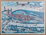 |
Georg Braun and Frans Hogenberg. Arnsberg. Handcolored engraving from Civitates Orbis Terrarum by Braun (1541-1622) and Hogenberg (1535-90), c. 1572-1617. Image: 12½ x 16¾", matted and framed to 22¾ x 27". Title in small baroque cartouche. Not examined out of frame. The six volumes of Civitates Orbis Terrarum, produced by Braun and Hogenberg and sometimes using drawings by Joris Hoefnagel, a professional topographical artist, contained over 500 city views and maps and was one of the most important works in the history of cartography and topography. After 1618 there were a number of re-issues and the plates were eventually aquired by Jan Jansson who published an eight volume edition. Thereafter the maps were re-issued a number of times in various forms and were published for the last time in 1750.
Estimated Value $400 - 600.
View details and enlarged photo
| Realized
$234 |
Lot 313 |
 |
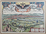
Georg Braun and Frans Hogenberg. Brema. "Vrbs Hanseatici Foederis Ad Visvrgvm Flv. Valide Mvnita Mercimoniis Dives Et Elegans." Handcolored engraving of the city of Bremen from "Civitates orbis terrarum" (Cologne, 1598). Text in Latin. Image: 13 5/8 x 18¼, matted and framed to 24¼ x 28¾". A few nicks to frame. Not examined out of frame. Prints such as this one give us a great deal of information about British architecture and landscape design. Fine. Not examined out of frame. After 1618 Jan Jansson aquired the plates for Civitates orbis terrarum and published an eight-volume edition. The maps were re-issued a number of times in various forms and were published for the last time in 1750.
Estimated Value $300 - 500.
View details and enlarged photo
| Unsold |
Lot 314 |
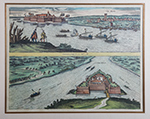 |
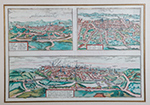
Georg Braun and Frans Hogenberg. Comorra. By Joris Hoefnagel and Jakob Hoefnagel. Handcolored engraving, two views on one sheet, Cologne, c. 1595. Below top engraving: "Communicavit G. Houf. Ao. 1595 depict. a filio." Image: 14 x 18¼", matted and framed to 24½ x 28½". In the top scene, a sea battle is going on. In the bottom scene, both land and sea forces are engaged in battle.
Estimated Value $400 - 600.
View details and enlarged photo
| Unsold |
Lot 315 |
 |
Georg Braun and Frans Hogenberg. Montpellier - Tours - Poitiers. Handcolored engraving with bird's eye views of the three cities. From "Civitates orbis terrarum" (Cologne, 1598). Text in Latin. Image: 13¾ x 19¾", matted and framed to 23¼ x 29¼". A few nicks to frame. Key to locations for Montpellier and Tours. Cartouche for Poitiers states that Poitiers is the vernacular name for Pictavis or Pictavia, that it is the capital of the Pictavi or Pictones, known for its university, for the ruins of a large theatre, for ancient monuments, and for magnificent ecclesiastical and secular buildings. Captions of Poitier engravings are given in detail. Not examined out of frame.
Civitates orbis terrarum was one of the most important works in the history of cartography and topography. Georg Braun, who was Canon of Cologne Cathedral, compiled the text and Frans Hogenberg was the primary engraver, many of which were based on drawings by Joris Hoefnagel (1542-1600), who was a professional topographical artist. From 1572 to 1617 Braun and Hogenberg produced six volumes with over 500 city views and maps together with a large amount of textual information.
After 1618 Jan Jansson aquired the plates and published an eight-volume edition, after which time the maps were re-issued a number of times in various forms. They were published for the last time in 1750.
Estimated Value $400 - 600.
View details and enlarged photo
| Unsold |
Lot 316 |
 |
Georg Braun and Frans Hogenberg. Ratisbona. Handcolored engraving. Latin text, signed and dated at lower right by the draughtsman, Jakob Hoefnagel (1575-1630), Regensburg, 1594. Jakob was artist at the court of Rudolf II in Prague, as his father Georg had been before him. Image: 13 x 18", matted and framed to 23¼ x 28½". Some nicks to frame; not examined out of frame. There are two views of Regansburg in the "Civitates orbis terrarum"; this view is from a hillside overlooking the town and shows a great expanse of countryside in the forefront. Coats of arms across the top make this print especially appealing. "Civitates orbis terrarum" was the first systematic city atlas. It is difficult to differentiate between the various editions which were issued since the state of the plates and their number and order do not vary.
Estimated Value $400 - 600.
View details and enlarged photo
| Unsold |
Lot 317 |
 |
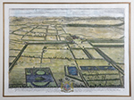
Johannes Kip and Leonard Knyff. Eaton Hall on the River Dee near the Citty of Chester in Cheshire. Handcolored engraving of "the Seat of the Honble. Sr. Thomas Grosvenor Baron.tt [1655-1700]". Image: 14½ x 18½, matted and framed. Not examined out of frame. A few nicks to frame. Knyff and Kip were both Dutch, the former a draughtsman and painter and the latter was a draughtsman and engraver. They made a series of engravings of the country houses of Britain, which were published in Britannia Illustrata or Views of Several of the Queen's Palaces also of othe Principal Seats of the Nobility and Gentry of Great Britain. The Queen referred to was Queen Anne (ruled 1702-14).
Estimated Value $250 - 350.
View details and enlarged photo
| Unsold |
Lot 318 |
 |
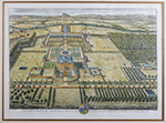
Johannes Kipp. Haughton, in the County of Nottingham. Handcolored engraving by Johannes Kipp (1653-1722), drawing by Leonard Knyff (1650-1722). Published in "Britannia Illustrata" (London, 1707), plate 16. Image: 18½ x 12½", matted and framed to an overall size of 24½ x 30". A few nicks to frame. Full text: "Haughton, in the County of Nottingham one of the Seats of the Most Noble and Mighty Prince John Duke of Newcastle Marquis and Earle of Clare Baron Haughton of Haughton Ld. Lt. of the County of Nottingham and of the Town and County of Nottingham Ld. Warden of the Forest of Shirwood and Knight of the Most Noble order of the Garter." Armorial in the center has mottos "Honi soit qui mal y pense" and "Spes audaces aduvat." Prints such as this one give us a great deal of information about British architecture and landscape design. Not examined out of frame.
Estimated Value $400 - 600.
View details and enlarged photo
| Unsold |
|
|


