|
Sale 76
Manuscript Sale
| Lot |
Photo |
Description |
Realized |
Lot 245 |
 |
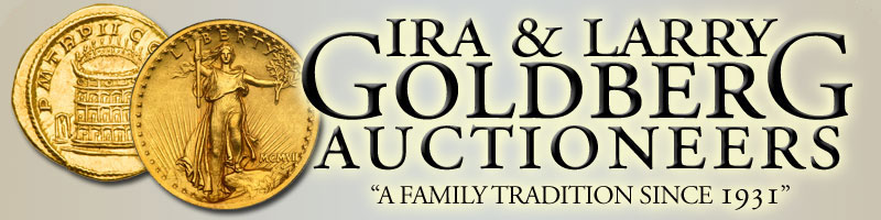
New York and Environs. By W.C. Rogers, 16½ x 12 in. Original print, not a copy from a book. Prepared for inclusion in the 1868 edition of Joseph Shannon's Manual of The Corporation Of The City of New York. Depicting the entire island of Manhattan with Hoboken as well as parts of Brooklyn and Queens. Important buildings, including churches are shown and sailing ships fill the harbor. The Clerk of the City of New York (Joseph Shannon at this time) was responsible for preparing an annual manual, which included facts about the City of New York, city council information, city history, and reported on the progress of public works such as Central Park. William C. Rogers was a New York-based lithographer best known for the engravings he made in the 1860s and 70s for Shannon's manuals. Estimated Value $2,000 - 3,000
View details and enlarged photo
| Unsold |
Lot 246 |
 |
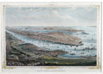
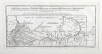
Côte Nord-Ouest de l'Amérique Reconnue par le Cape. Vancouver. Two copper-engraved charts, uncolored, each 24 x 29¾ in. From the French folio edition of Vancouver's voyages, Paris, 1800. Each part labeled "Part of the coast of New Albion." Part 1 extends from Bodega Bay, California to St. Domingo, Mexico; insets of the ports of San Diego and San Franciso. Spanish missions and presidios are noted. Part 2 shows the west coast from north of Cape Lookout, Oregon to south of Point Arena, California (Mendocino County). Inset of the Bay of Trinidad (in Humboldt County, Ca.). Light toning. Estimated Value $1,000 - 2,000
View details and enlarged photo
| Unsold |
Lot 247 |
 |
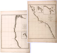
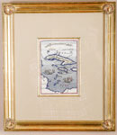
de Vaugondy. Carte de la Californie et des Pays Nord Ouest and Carte Générale des Découvertes de l'Amiral de Fonte. Two hand-colored engravings from Diderot's Encyclopedia. The first is "extracted from two maps published at the beginning of the 17th century," and is a study in the cartography of the West Coast of North America, from the Straits of Anian to Cabo San Lucas and the southern tip of Baja California. Published in 1772. Sight: 14¼ x 12 in; framed: 20 x 18 in. Inset shows the Straits of Anian with an open sea above, suggesting a northwest passage in the Arctic Circle. Fine; not viewed out of frame. The Carte Générale, published in 1779, is based on the work of de l'Isle, and shows the fictitious discoveries of Admiral de Fonte, covering the North Pacific, Japan, Russia, Alaska, and California; it also shows the mythical Northwest passage and a Sea of the West. In the Pacific, voyages of actual explorations by Bering, Chirikov and de Frondat are shown. Sight: 15 x 11¾ in.; framed: 20½ x 17½ in. Fine; not examined out of frame. Estimated Value $500 - 600
View details and enlarged photo
| Realized
$300 |
Lot 248 |
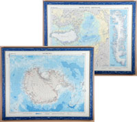 |
Maps of North and South Poles, by J. Bartholomew. London, 1957-59. Original color lithograph "Antarctica" and "Arctic Ocean Greenland"; each 24 x 19 in. and framed to 26¼ x 21 in. Antartica shows the South Polar landmass from the "Times Atlas of the World". Dated July 57 but overprinted with the route of Sir Vivian Fuchs' Commonwealth Trans-Antarctic Expedition which ended in March 1958. Identifies bases and locations reached by various 20th century explorers. The second map shows the north polar regions to the Arctic Circle. Shows the route of the nuclear-powered U.S. submarine "Nautilus" beneath the ice pack in August 1958. Inset detail of the Greenland coastal strip showing fjords and glaciers. Estimated Value $400 - 600
View details and enlarged photo
| Unsold |
Lot 249 |
 |
Carte du Cours du Maragnon ou de la Grande Rivière des Amazons. 15½ x 7¼ in. (plate). Matted and beautifully framed to 29¾ x 23¾ in. Translated: Map of the Maragnon or Grand River of the Amazons. From its navigable part from Jaen de Bracamoros to its mouth and comprising the province of Quito, and the Cote de la Guiane (Guyana Coast) from the Cap du Nord (North Cape to Essequebe. Done in 1743 & 1744 and subject to the astronomical observations by M. de la Condamine. Detailing of the Rivière Noire (Black River) and other details taken from memoirs and traveling manuscripts of modern voyagers. Fine. Estimated Value $300 - 500
View details and enlarged photo
| Unsold |
Lot 250 |
 |
Is. de Cuba et de Iamaica, by A. Mallet. Paris, c. 1683, 4½ 6¼ in. Hand-colored copper engraving published in Allain M. Mallet's "Description De L'Univers, Contenant Les Différents Systèmes Du Monde, Les Cartes générales & particulières …" Small map showing Cuba, Jamaica and the Cayman Islands, which are named on this map: San Spirito, C. Nigrello and C. Nigritto. Florida and the Bahamas are shown on the horizon. Foreground has numerous sailing ships engaged in battle. Framed: 12¼ x 14 in. Estimated Value $150 - 200
View details and enlarged photo
| Realized
$132 |
Lot 251 |
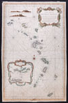 |
Bellin, Jacques Nicolas. Carte Reduite des Isles Antilles…Pour le Service des Vaisseaux du Roi. Paris : [Département de la Marine], 1758. Sheet size: 35½ x 23", hand colored. A very attractive, detailed sea chart on two joined sheets covering the region from the Virgin Islands to Grenada. Lovely decorative title cartouche and inset: "Carte particulière des Isles des Vièrges" within a decorative cartouche; also, two views of the Island of Saint Eustatius in the Dutch Antilles. On very thick paper; minor soiling; one light damp stain at lower edge. An uncommon map. Bellin was the senior hydrographic engineer of the Dépôt de la Marine. He wrote a five-volume treatise on Gulf Navigation in 1749. Estimated Value $250 - 350
View details and enlarged photo
| Realized
$154 |
Lot 252 |
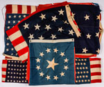 |
The Dr. Charles L. Ruby Collection of American Flags. A group of six American flags of various sizes, all well before 1959. Made of wool and linen, and some exhibiting age (moth) damage (or perhaps bullet holes)! Includes newspaper articles about these flags as well as some correspondence. We note one flag that reportedly came from post-colonial New Hampshire. We urge inspection prior to bidding as there could be a treasure trove here. SOLD AS IS. Estimated Value $500-UP
View details and enlarged photo
| Realized
$528 |
|
|


