|
Sale 52
Manuscript, Collectibles and Aerospace Auction
| Lot |
Photo |
Description |
Realized |
Lot 320 |
 |
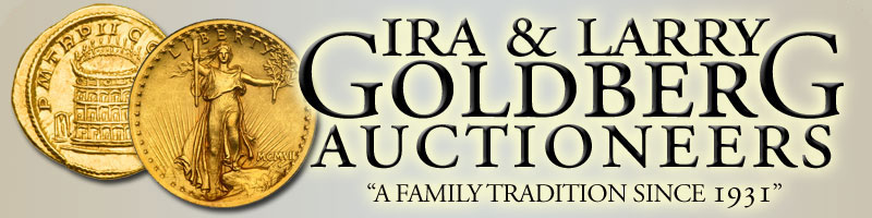
1779 DeVaugondy Map Of North Pacific. This is a chart of the discoveries of Admiral DeFonte by De Vaugondy. An original engraving, colored from Diderot Encyclopedia, it covers the North Pacific, showing Japan, Russia, Alaska, and California. It also shows the mythical Northwest Passage and the Sea Of The West---all inaccurate by today's standards. The map measures 11¾ x 14½; framed to 17 x 20". Very good.
Estimated Value $850 - 1,000.
View details and enlarged photo
| Unsold |
Lot 321 |
 |
Limited Edition Set of Twelve West Coast Maps-. A unique collection of maps, originally drawn before the Revolutionary War; this set printed in 1985. Outstanding cartographic quality, only 500 were printed of each. Included are names such as Mercator, Dudley, Goos, Blaeu, and Faz Dourado. In the portfolio there is a monograph of 32 pages, illustrated in full color, on the history of maps, charts and their makers and in periods of American history that can be traced from the maps and charts. Pages measure 18 x 20". Printed in 1985. Near Mint.
Estimated Value $750 - 900.
View details and enlarged photo
| Unsold |
Lot 322 |
 |
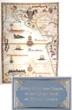
L'Amerique Septentrionale and Meridionale, 1690 - California As An Island. Two separate maps, each from an atlas by Ogier and each about 6 x 8", on laid paper. North America has a small title cartouche of a woman seated with a sword and a seated man. South America has a small cartouche of two Indians holding an arrow and a tomahawk; both cartouches have palm trees. Erroneous geographical information on the North American map, which predate Lewis and Clark's expedition by over 100 years, includes: California depicted as an island, Greenland touching Canada on top and in the West, and much of the West and Northwest basically blank. Florida's tip bends inward toward the Golf. The map of South America lacks the Andes. Both maps in fine condition.
Estimated Value $600 - 700.
View details and enlarged photo
| Unsold |
Lot 323 |
 |
Four Maps of U.S. Geological Survey. A series of four maps including Catalina Islands, U.S. Coast Survey of San Francisco Bay and Vicinity (1852), Humboldt Harbor, California (1891), and Cylers Harbor, California (San Clemente Harbor).
Good to very good.
Estimated Value $400 - 500.
View details and enlarged photo
| Unsold |
Lot 324 |
 |
Early Mexico City Birds Eye View Map. A lovely view, ca. mid-17th century to perhaps early 18th century, with old hand coloring, of Mexico City from a high vantage point. Shown are sailing ships, people, the old walled city with large and small buildings, monuments, etc. Printed area 10½" wide by 7¾ " high, with additional margins. Nicely matted and ready for framing. Very good condition.
Estimated Value $300 - 500.
View details and enlarged photo
| Unsold |
Lot 325 |
 |
DeVaugondy Map of America. A 1772 De Vaugondy map of the North and West of America measuring 11¾ x 14¾"; matted to 24¾ x 31½". Very good.
Estimated Value $300 - 400.
View details and enlarged photo
| Unsold |
Lot 326 |
 |
Map Of Principal Rivers And Mountains Of The World. A large format example of this mountains and rivers plate, showing the lengths of the principal rivers of the world and heights of the principal mountains. Delineates volcanoes, mountain lakes, and other features. Includes names and distances and identifies continents. The reverse has a listing of all mountains, rivers, and lakes. It was published in New York in 1855. This hand colored piece measures 24 x 17". Very good.
Estimated Value $300 - 450.
View details and enlarged photo
| Unsold |
Lot 327 |
 |
Topographical Map Of YosemiteValley. United States Department Of The Interior geological survey map of Yosemite Valley, Yosemite National Park, California, and Mariposa County. Printed in 1838, it measures 37¾ x 18". Very good.
Estimated Value $175 - 275.
View details and enlarged photo
| Unsold |
Lot 328 |
 |
Thompson and West Original Plate From The History Of Los Angeles County. A diagram of the property of J.A. De Celis and Sons. Sixty acres, corner of Main and Washington Streets, Los Angeles, California. Measures 10 x 12¾, and matted to 15 x 17¾". Very good.
Estimated Value $150 - 200.
View details and enlarged photo
| Unsold |
Lot 329 |
 |
Map of British Empire. 1899 map of British Empire measuring 19¾ x 14". Very good.
Estimated Value $100 - 150.
View details and enlarged photo
| Realized
$98 |
Lot 330 |
 |
1780 Map of New Jersey. "A New and Accurate Map of New Jersey, from the best Authorities," 12¾ x 11¼. The date 1780 is penciled in, probably because the map came from an issue of "The Gentleman's Magazine," which often published maps of the American colinies so that its London readers could better understand what was happening in the Revolutionary War. The map also shows part of New York, Pennsylvania, and Delaware. Light toning.
Estimated Value $75 - 100.
View details and enlarged photo
| Unsold |
Lot 331 |
 |
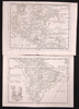
A New General Atlas, 1721. A massive English atlas, 21½ x 13", 261pp plus extensive index with complete geographical descriptions of the known world, very extensive geography information of England, Scotland, Wales, and Ireland. Lacking title page and maps (with which it would sell in the $30,000 to $40,000 range). Still rare in any state, as the edition was quite low. Original old worn leather board covers, hinges loose but intact. Internally very bright and clean. The descriptions include histories such as that of the Holy Land, the Mogul Empire and China, the large section on Africa, and, of course, the British Empire in North America. Filled with a plethora of town names, rivers, and anecdotal histories.
Estimated Value $600 - 800.
View details and enlarged photo
| Unsold |
Lot 332 |
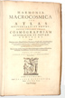 |
Cellarii, Andreae. Harmonia Macrocosmica Sev Atlas Universalis et Novus…. Amsterdam: published by Jansson, 1661. 213pp, elephant folio (20½ x 13½"), weighing 10 pounds. Text in Latin; plates were removed long ago (with the plates the volume would sell in the $50,000-60,000 range). A new universal atlas, including cosmography of the planets with the Copernicus planet system. Printed on high-quality paper with original vellum and gold stamped boards. The text is replete with the burgeoning new information of our galaxy and the cosmos, as a result of the invention of the telescope and the discoveries of Galileo. Published just 32 years after Galileo was condemned by the Inquisition for asserting that the Earth was not the center of the universe.
Estimated Value $1,000 - 1,500.
View details and enlarged photo
| Unsold |
Lot 333 |
 |
Two Battle Maps Of The War with Mexico. One map show the actions fought at San Pascal in upper California between the Americans and the Mexicans, December 6 and 7, 1846. The second map shows The Battle of Sacramento, February 28, 1847. Very good.
Estimated Value $200 - 300.
View details and enlarged photo
| Unsold |
|
|


