
|
Sale 33
Manuscript and Collectibles Auction
| Lot |
Photo |
Description |
Realized |
Lot 418 |
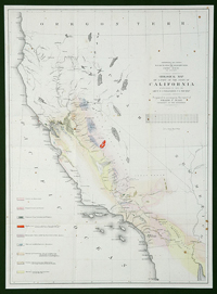 |
Geological Map of A Part of the State of California Explored In 1855 By Lieut. R.S. Williamson…. "Prepared to Accompany the Report of William P. Blake, Geologist of the Expedition." Made for the War Department: "Explorations and Surveys For A R.R. Route From the Mississippi River to the Pacific Ocean." Lithograph of Sarony, Major & Knapp, N.Y. Delicate handcoloring, 22"x16". From Volume V of the Pacific Railroad Surveys (1855), defining the various geological regions of the state. Attractively matted and framed to an overall size of 31'x25".
Estimated Value $400 - 600.
View details and enlarged photo
| Unsold |
Lot 419 |
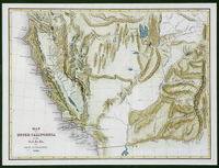 |
Map of Upper California By the U.S. Ex. Ex. And Best Authorities. 1849. Handcolored, 8½"x11". Important map of the West, first issued to accompany Charles Wilkes' report of the US Exploring Expedition West of the Rocky Mountains, 1841-45. In the West, it extends from Klamet Lake down to the Mexican border, and in the East to the Anahuac Mountains and the sources of the Green River and Colorado River in the East. It incorporates the discoveries of Wilkes, Fremont, and others. Wheat 458. Very fine.
Estimated Value $300 - 500.
View details and enlarged photo
| Realized
$180 |
Lot 420 |
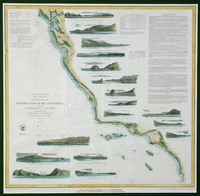 |
"Reconnaissance of the Western Coast of the United States from San Francisco to San Diego." Published by the U.S. Coast Survey under A.D. Bache, Superintendent, 1853, "Corrected to 1864," 22¾"x22¾". From the first official scientific reconnaissance of the Pacific coast, showing the coastal littoral, naming hidden dangers and shoals, giving tides, offshore soundings, and general sailing instructions into San Francisco Bay, Monterey Harbor, Catalina Harbor, and San Diego. Seventeen views show entrances and promontories along the coast, including Catalina, Santa Barbara, Moro Rock, and others. Fine except for folds and a couple of minor spots. Attractively matted and framed to 30"x30½".
Estimated Value $300 - 500.
View details and enlarged photo
| Realized
$192 |
Lot 421 |
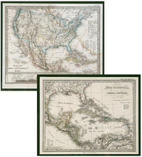 |
Two Maps: The U.S. & Mexico, and the West Indies and Central America. Two Italian maps : "Stati Uniti dell' America Settentrionale e Messico" and "Indie Occidentali e America Centrale," from an atlas, c. late 1850s, Gotha: Giusto Perthes. The first is 8"x10", matted and framed to 15½"x17½" and color coded to denote countries, states, and territories; the second is 7¼"x9½", matted and framed to 15½"x17½" and coded by languages. Both are fine except for minor foxing to the first.
Estimated Value $500 - 600.
View details and enlarged photo
| Unsold |
|
|


